Hurricane Beryl's emergence in 2024 was a stark reminder of the shifting dynamics in our climate. From its rapid intensification to its record-breaking strength, Beryl's journey highlighted the growing unpredictability and power of tropical storms. As we examine its path and impact, we uncover critical insights into the future of hurricane seasons and the pressing need for enhanced preparedness.
Formation and Rapid Intensification
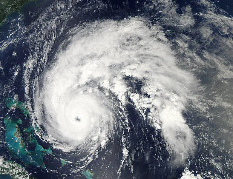
Hurricane Beryl's genesis began on June 28, 2024, as a modest tropical depression with winds clocked at 35 mph. Within just 24 hours, Beryl escalated to a full-fledged hurricane, boasting winds of 75 mph. This marked the farthest east a hurricane had formed in June, a concerning trend scientists attribute to climate change.
The ocean was exceptionally warm, with sea surface temperatures in the main development region of the Atlantic near record highs. This warmth fueled Beryl's rapid growth. By July 1, it barreled into Carriacou Island with devastating force, packing sustained winds of 150 mph. On July 2, it became the earliest Category 5 hurricane recorded in the Atlantic, reaching peak winds of 165 mph.
The environmental setup favored Beryl's intensification:
- Ocean temperatures were exceptionally warm
- Signs of an impending La Niña created conducive conditions
- Low wind shear allowed for unimpeded growth
Fewer than 5 hurricanes per 100 years develop where Beryl did in June or July, making it a significant anomaly.1
"Beryl's early development is remarkable." – Matthew Rosencrans, NOAA's Climate Prediction Center
Beryl's journey continued:
- July 1: Catastrophic impacts to the southern Windward Islands
- July 3: Hit Jamaica as a Category 4 storm
- July 4-5: Crossed the Yucatan Peninsula, weakening temporarily
- July 6-7: Regained strength in the Gulf of Mexico
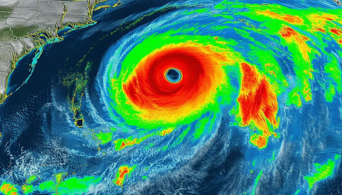
- July 8: Made landfall in Texas with sustained winds of 70 mph and gusts hitting 92 mph
Beryl's profound strength and rapid intensification serve as a warning sign for what the 2024 hurricane season might have in store.
Record-Breaking Metrics
Beryl's rapid ascent shattered numerous records:
- Earliest Category 5 hurricane on record, surpassing Hurricane Emily's 2005 record by two weeks
- Most powerful July hurricane in Atlantic history with 165 mph winds
- First-ever Category 4 hurricane to form in June
- Rocketed from tropical depression to major hurricane in just 42 hours
Geographically, Beryl formed farther east in June than any other hurricane. By the time it reached Category 3 intensity near the Lesser Antilles, it was nearly 2,000 miles east of where the precedent had been set by 1966's Hurricane Alma.
Beryl's maximum sustained winds hit the 150 mph mark earlier than any storm in history, besting the previous record held by Hurricane Dennis in 2005 by a week. Its journey from a tropical depression to a Category 3 hurricane in such a short span set new records for rapid intensification.
Each of these milestones underscores a troubling reality: hurricanes are becoming more potent and forming earlier in the season. As ocean temperatures rise and wind shear diminishes due to phenomena like La Niña, we're entering an era where once-rare storms are occurring with disturbing frequency.
Beryl's records serve as a cautionary tale about the heightened vigor lurking in the warm waters of the Atlantic, setting a heavy precedent for future tropical systems.
Impact on Affected Regions
Beryl's devastating journey left an indelible mark on multiple regions:
Windward Islands
- Carriacou Island faced Category 4 winds
- Roofs torn from homes, power lines obliterated
- Storm surge swallowed coastal dwellings
- Insurable losses: $1-$1.5 billion2
Jamaica
- Hit as a Category 4 hurricane
- Southern coast severely battered
- Utility poles snapped, roads impassable
- Economic losses: $400-$700 million
Yucatan Peninsula
- Weakened to Category 2, but remained formidable
- Winds gusting upwards of 110 mph
- Tourist areas from Cancun to Tulum impacted
- Estimated losses below $1 billion
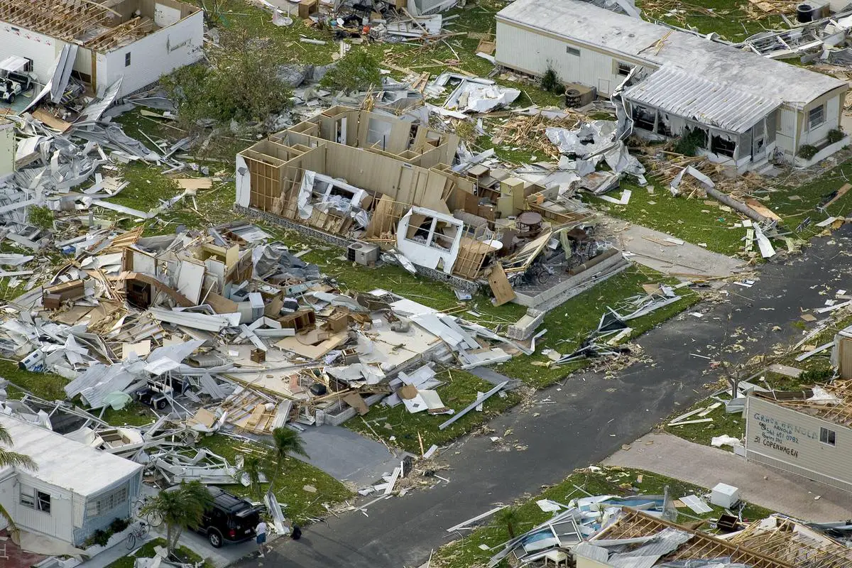
Texas
- Landfall near Matagorda as Category 1
- Wind speeds: 70 mph, gusts to 92 mph
- Storm surge up to five feet
- Houston faced torrential rain, overwhelming bayous and drainage systems
- 7 lives lost, 2+ million without power
- Insurable losses: $700 million – $1.5 billion
From the Caribbean islands to the Texan coast, Hurricane Beryl demonstrated the sheer power and unpredictability of nature magnified by an increasingly unstable climate. As communities begin the arduous task of rebuilding, the memories and lessons of Beryl's wrath will linger long after the final gusts have passed.
Comparisons to Past Hurricanes
Beryl's comparison to past hurricanes reveals both similarities and differences, highlighting the evolving dynamics of these powerful storms. Hurricane Emily in 2005 previously held the record for the earliest Category 5 hurricane, reaching this strength on July 16. Beryl broke this record by over two weeks, demonstrating unusually rapid intensification for so early in the season. Beryl's peak winds of 165 mph surpassed Emily's 160 mph, illustrating how warming ocean temperatures can fuel even greater destructive power.
Emily's path in 2005 took it through Caribbean islands and Mexico's northeastern coast. Beryl, however, traced an unprecedented route farther east and then north, affecting regions from the Windward Islands to Texas. This geographical spread suggests shifting Atlantic hurricane patterns influenced by global climate changes.
Hurricane Dennis, another significant storm from 2005, reached Category 4 status by July 8. Beryl's Category 4 classification on June 30 broke this record as well. Dennis caused major damage in Cuba and along the U.S. Gulf Coast, similar to Beryl's path of destruction, though later in the season.
Comparing Beryl to Hurricane Harvey (2017) offers insight into recent powerful Atlantic storms. While Harvey was notorious for catastrophic rainfall and flooding in Texas, Beryl's impact came more from its intense storm surge and high winds. Beryl's speedy progression combined with powerful gusts led to severe inland flooding, extensive power outages, and considerable infrastructure damage.
Hurricane Ike in 2008 presents another analogous storm in Houston's recent history. Like Ike, Beryl caused substantial damage from its storm surge and created severe localized flooding. The impacts of Beryl highlight how Houston continues to grapple with hurricane-related challenges despite recovery efforts from past storms.
Key Comparisons:
- Beryl vs Emily: Earlier Category 5 formation by two weeks
- Beryl vs Dennis: Earlier Category 4 formation
- Beryl vs Harvey: Different impact mechanisms (surge/winds vs rainfall)
- Beryl vs Ike: Similar storm surge effects on Houston
Beryl's rapid escalation and widespread path stand out when compared to these past hurricanes. It combined aspects of several storms – early rapid intensification like Emily and Dennis, severe precipitation impacts reminiscent of Harvey, and the combined wind and flood dynamics seen with Ike.
The record-breaking pace at which Beryl formed, intensified, and carved its path across diverse territories underlines a growing trend towards earlier and more aggressive storm developments. These comparisons emphasize that we're entering an era of storms that not only break past records but redefine expectations for future Atlantic hurricane seasons.
Future Implications
Hurricane Beryl's unprecedented power and early appearance in the Atlantic hurricane season have significant implications for the future. The storm's trajectory underscores a critical point: future hurricane seasons may bring similar or greater dangers. The role of climate change is central to understanding these potential risks.
Climate change contributes to the intensification and frequency of hurricanes. Warmer ocean temperatures, like those that fueled Beryl, provide more energy for storms to grow stronger quickly. This is compounded by changes in atmospheric conditions, such as reduced wind shear, which allow storms to maintain or increase their intensity. With Atlantic basin sea surface temperatures consistently above average in recent years, we can anticipate more storms like Beryl – early, powerful, and highly disruptive.1
The overall pattern of hurricane seasons is shifting. Storms are forming earlier and maintaining strength longer, pushing the boundaries of traditional hurricane season norms. La Niña events, which reduce wind shear in the Atlantic and foster hurricane development, may become more impactful as global sea temperatures rise. As a result, regions previously considered safe may now find themselves at risk, necessitating a reevaluation of preparedness strategies.
"As our climate continues to warm, we expect to see more intense hurricanes forming earlier in the season, potentially causing unprecedented damage."
Preparedness is crucial for communities in hurricane-prone areas. This includes not just immediate response measures, but also long-term planning to reinforce infrastructure, enhance early warning systems, and develop comprehensive evacuation plans. Public awareness and education play a vital role; communities need to understand the risks and have access to resources that can help mitigate those risks.
Investing in advanced forecasting models is equally essential. Enhancing our predictive capabilities can save lives and allow for more effective mobilization of resources before a hurricane makes landfall. Improved satellite technology, climate modeling, and data analytics offer promising advances in this area.2
Key Areas for Future Focus:
- Climate change mitigation efforts
- Enhanced hurricane preparedness strategies
- Advanced forecasting technologies
- Infrastructure reinforcement
- Public education and awareness campaigns
The repercussions of hurricanes are not confined to the areas they directly hit. Economic disruptions from storms can ripple through supply chains, affecting industries and economies globally. Proactive measures in infrastructure reinforcement, such as flood defenses and storm-resistant building codes, can mitigate these far-reaching effects.
Beryl's legacy will be one of lessons learned and strategies refined. Each storm provides data and insights that can improve our understanding of hurricane dynamics and better prepare us for future events. As Beryl's impact fades into history, the urgency to act on the knowledge it brings remains. Communities, governments, and global organizations must collaborate to enhance resilience to what seems to be an increasingly volatile climate landscape.

Hurricane Beryl's unprecedented power and early appearance serve as a stark warning about the future of our climate. Its rapid intensification and widespread impact underscore the urgent need for comprehensive preparedness and advanced forecasting. As we move forward, the lessons from Beryl remind us of the importance of safeguarding lives and livelihoods against nature's most formidable forces.
![]()
Thanks I have just been looking for information about this subject for a long time and yours is the best Ive discovered till now However what in regards to the bottom line Are you certain in regards to the supply.